


-
First page
- Upazila related
-
Upazila Parishad
Minutes of Upazila Committee Meetings
-
Law and Order Committee
-
Communication and Physical Infrastructure Development Committee
-
Agriculture and Irrigation Committee
-
Secondary and Madrasa Education Committee
-
Primary and Mass Education Committee
-
Health and Family Welfare Committee
-
Youth and Sports Development Committee
-
Women and Child Development Committee
-
Social Welfare Committee
-
Freedom Fighters Committee
-
Fisheries and Livestock Committee
-
Rural Development and Cooperatives Committee
-
Cultural Affairs Committee
-
Environment and Forest Affairs Committee
-
Market Price Monitoring, Inspection and Control Committee
-
Finance, Budget, Planning and Fixed Asset Acquisition Committee
-
Committee on Public Health, Sanitation and Clean Water Supply
-
Law and Order Committee
- Upazila administration
- Municipality
- Government office
- Different Institutions
- E-services
- Gallery
- national anthem
-
First page
-
Upazila related
Upazila introduction
History and tradition
Geographical and economic
-
Upazila Parishad
Thakurgaon Sadar Upazila Parishad
Monthly Meeting Resolution
Minutes of Upazila Committee Meetings
- Law and Order Committee
- Communication and Physical Infrastructure Development Committee
- Agriculture and Irrigation Committee
- Secondary and Madrasa Education Committee
- Primary and Mass Education Committee
- Health and Family Welfare Committee
- Youth and Sports Development Committee
- Women and Child Development Committee
- Social Welfare Committee
- Freedom Fighters Committee
- Fisheries and Livestock Committee
- Rural Development and Cooperatives Committee
- Cultural Affairs Committee
- Environment and Forest Affairs Committee
- Market Price Monitoring, Inspection and Control Committee
- Finance, Budget, Planning and Fixed Asset Acquisition Committee
- Committee on Public Health, Sanitation and Clean Water Supply
Fiscal year budgets
Annual Development Plan
List of development projects
five year plan
Resources Registo 2023-2024
Upazila Management and Development Project (UGDP)
Financial Statement of Upazila Parishad
Upazila Annual Purchase Plan for the financial year 2023-24
-
Upazila administration
Upazila Nirbahi Officer
About Organogram
Schedule & Meeting
- Municipality
-
Government office
Law, order and security
Education and culture
Agriculture, fisheries, animal and food
Health and environmental
Engineering and information and communication technology
Human resource development
Land and revenue
-
Different Institutions
Educational Institutions
Non-Govt. Organizations
-
E-services
Fidom Faiter Talika
National E-Service
- Gallery
-
national anthem
National Anthem (Audio)
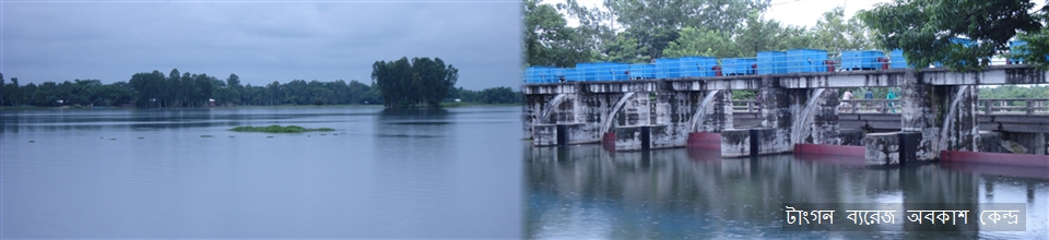
The rivers of Tangan, Kulik and Nagar are generally flowing from north to south. Although not throughout the year, the rivers regain their youth during the rainy season. Extreme levels of flood danger were announced in at least two places. However, the region is especially flooded during the monsoon. Pirganj, Haripur and Sadar upazilas have low water bodies. However, in the dry season, they remain completely dry. The course of the river is slowly shrinking due to siltation. Apart from rivers, there are many canals in this area. There is enough water in the canal beel during the monsoon season. However, most of the canals dry up during the dry season. Only some of the larger bills contain water.
Tangan River: The Tangan River originates from the lower waters of Atwari upazila of Panchagarh district bordering India and Bangladesh and flows southwards through Bochaganj upazila of Dinajpur. The river then enters Balurghat in India and re-enters Bangladesh and joins the Punarbhara river at Chapai Nawabganj. Eventually this combined current merged into the Mahananda river near Rohanpur. Thakurgaon Sadar is located on the left bank of this river. From Tangan and other major rivers, tributaries and tributaries named Shuk, Senua, Mara Pathraj and Charalban have originated.


Planning and Implementation: Cabinet Division, A2I, BCC, DoICT and BASIS
Technical Assistance:
![]()
Developed By:
